
 Click on photo for more information.
Visiting Sacatar Tail Wilderness
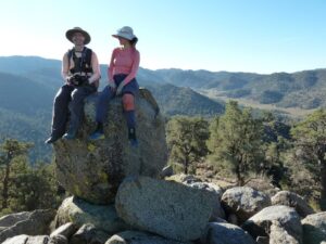
by Laurie Schwaller
Sacatar Trail Wilderness, truly wild, straddles the Southern Sierra crest in southeastern Tulare County. Protecting highly diverse, almost trackless, pristine landscapes virtually unaltered by human presence, Sacatar invites visitors to experience public lands in their most natural state. Elevations from 3,500′ to 8,800′ host plant life from cactus and desert shrubs through pinyon-juniper woodland to ponderosas and red fir stands with related wildlife. Hikers, backpackers, and peakbaggers who value solitude, discovery, and a sense of the unknown, and are experienced, self-reliant, and well-prepared, will relish time spent in this intriguing, wide-ranging wilderness.
The Sacatar Trail Wilderness was established on October 31, 1994, through the California Desert Protection Act (Public Law 103-433), which enlarged Death Valley and Joshua Tree National Monuments and converted them into National Parks, established the 1.6 million acre Mojave National Preserve, and set aside an unprecedented 9 million acres of Wilderness. (Motorized vehicles and equipment are now prohibited, with a very few exceptions, on all federal wilderness lands.)
Probably tracking a long-used Indian path for hunting, gathering, and trade, the Sacatar Trail was originally constructed to be a wagon road, hacked out and up and over the crest of the Southern Sierra Nevada with great difficulty to facilitate travel of the military, cattle drovers, traders, and other commercial users between the Owens Valley on the east and the Kern River Valley and San Joaquin Valley on the west side of the Sierra. But by the later 1800s, almost all the traffic that had been taking the Sacatar Trail had chosen to take the more southerly and 2,000′ lower route over Walker Pass instead. Today, the Sacatar wagon road, unmaintained for many years even as a foot trail, has dwindled to a mere “route,” as nature reclaims this ancient passageway through the wilderness.
March 2026
NOTE: The Project Team will be conducting research for a full article as volunteer time allows. Contact us if you’d like to help research, write about, and/or illustrate this Treasure!
NOTE: There is no quick way to get to Sacatar Trail Wilderness from Visalia.
From Visalia, go west on Hwy 198 and then south on Hwy 99 toward Bakersfield. At Delano, take Hwy 155 east (left) toward Glenville and Lake Isabella. Follow Hwy 155 as it goes south along the lake to its junction with Hwy 178. Go left (east) on Hwy 178 for about 30 miles to the Canebrake Flat area where you’ll go left (north) on rugged, graded-dirt, high-clearance, 4-wheel-drive vehicle recommended* Canebrake Road (AKA Chimney Peak Backcountry Byway) toward Chimney Creek campground.
Approximately 9 miles up from Hwy 178 is the junction of Canebrake and Long Valley/Chimney Basin roads. Continue on Canebrake Road past the campground and on to the junction with Road J41/Kennedy Meadows Road. Go left (north) on this road into Big Pine Meadow, at which point the Wilderness begins a short distance from the east (right) side of the road. (Chimney Peak Wilderness is on the west side of the road.) Farther north, a dirt road goes off to the right to a landing strip and Sacatar Meadow, at which point the Wilderness is again nearby on the right.
NOTE: There are no official trailheads for this western side of the Wilderness because there are no trails, but it can be accessed from a number of turnouts along J41 (AKA Sherman Pass Rd./Kennedy Meadows Rd.) through BLM land and also from the dirt ranch road to the north. Be aware of the “unattended property” regulation; it’s safest to not leave your vehicle for more than 71 hours. Also beware of trespassing; use GPS/surface management maps to ensure you’re not trespassing on or hiking over private, non-BLM lands.
Bakersfield BLM recommends driving about 1/4 mile south of the BLM Chimney Peak Work Center and Fire Station at 106490 Kennedy Meadows Rd. (AKA Sherman Pass Rd./J41) to find a couple of non-maintained dirt roads on the east side of J41 (35.866642, -118.008449). “The hike in depends on 4×4 capability and comfortability and you’ll hit Wilderness around .5 mi. to the east and 5 mi. to the north. It was signed at one point.”
You can also access this Wilderness from the east side of the Sierra if you stay on Hwy 178 east past Walker Pass and down to its junction with Hwy 14. Go north on Hwy 14 to its junction with Hwy 395 and go left (north) on 395 to just a few miles north of Little Lake in Rose Valley where you can find the Sacatar Trail, which goes up the edge of Little Lake Canyon to a 7,400′ pass in the Sierra and then descends on the west side via Sacatar Canyon. NOTE: Signage is minimal, making this trailhead difficult to find; carry a topo map (Little Lake quad) or BLM map of the area. Also, the ascent from the east side up to the pass is considerably steeper than the ascent from the west. ALSO: Per BLM-Ridgecrest, the Sacatar Trail could better be called a “route,” rather than a trail, since it has been unmaintained for many years. “The trailhead coordinates on Ridgecrest BLM land are 35.970704, -117.962829. The designated route is called RC997 off Hwy 395. This is the easiest way to access the wilderness and ‘trail'” on the east side.
*If your vehicle might have trouble with Canebrake Rd., you can continue on Hwy 178 past Canebrake to Hwy 14 north and Hwy 395 north to the junction with Rd. J41/Nine Mile Canyon Rd., which becomes Kennedy Meadows Rd., and follow it to Big Pine Meadow, as above.