Click on photo for more information.

Visiting Chimney Peak Wilderness

by Laurie Schwaller

     Tulare County’s southeast corner contains most of rugged, scenic Chimney Peak Wilderness:  over 13,000 acres of pinyon pine covered mountains (Chimney Peak reaches almost 8,000′), occasional springs and streams supporting lusher riparian areas (find trout in Chimney Creek), desert plants including Joshua trees and creosote bushes in the lower elevations, and sage brush in between, home to bears, mule deer, bobcats, mountain lions, wonderful wildflowers (seasonally), and plenty of solitude — plus eight miles of the Pacific Crest National Scenic Trail, and the Chimney Peak Backcountry Byway along its boundary line.

November, 2025

NOTE: The Project Team will be conducting research for a full article as volunteer time allows.  Contact us if you’d like to help research, write about, and/or illustrate this Treasure!  


Maps & Directions:


From Visalia, go west on Hwy 198 and then south on Hwy 99 toward Bakersfield. At Delano, take Hwy 155 east (left) toward Glenville and Lake Isabella. Follow Hwy 155 as it goes south along the lake to its junction with Hwy 178. Go left (east) on Hwy 178 for about 30 miles to the Canebrake Flat area where you’ll go left (north) on rugged, graded-dirt, high-clearance, 4-wheel-drive-vehicle-recommended Canebrake Road (AKA Chimney Peak Backcountry Byway) toward Chimney Creek campground.

Approximately 9 miles up from Hwy 178 is the junction of Canebrake and Long Valley/Chimney Basin roads.* Chimney Peak Wilderness is on the left as you continue on Canebrake Road or on the right if you continue onto Long Valley/Chimney Basin Road.

*NOTE: Per BLM, best on-trail access to Chimney Peak Wilderness is on Canebrake Road approximately 1.6 miles north of the prominent junction of Canebrake Road and Long Valley/Chimney Basin Road at a small Pacific Crest National Scenic Trail trailhead


Site Details & Activities:

Environment: 13,140 acres, rugged topography, elevation 5,246′-7,951′, pinyon-covered rocky mountains, canyons, sagebrush, scattered springs and streams with riparian habitats, Mojave Desert plants (e.g., Joshua trees and creosote bushes on valley floors, foothills, and alluvial fans), and overlapping ecosystems, includes about 8 miles of the Pacific Crest National Scenic Trail; Chimney Peak Wilderness is bordered by Domeland Wilderness on the west and Owens Peak Wilderness and Sacatar Trail Wilderness on the east
Activities: backpacking, birdwatching, botanizing, camping (free campfire permit required for gas lanterns, stoves, and campfires), dogs must be under owner’s control at all times and must not harass wildlife, fishing (with valid licenses and in compliance with state and local regulations), hiking (including 7 miles of Pacific Crest National Scenic Trail, along the valley of the South Fork Kern River, with the Rockhouse Trail continuing 4 more miles along the river), horseback riding and packing, hunting (seasonal, with valid licenses and in compliance with state and local regulations), mountaineering, photography, rock climbing, wildflower and wildlife viewing
Open: The Wilderness is always open, depending on weather, except when closed due to emergency conditions.
Site Steward: Bureau of Land Management, Bakersfield Field Office; 661-391-6000; BLM_CA_Web_BK@blm.gov (36,000 acres)
Opportunities for Involvement: Visit volunteer.gov or reach out to your local BLM office for information on opportunities near you.
Links:
BLM Chimney Peak Wilderness Information
BLM Chimney Creek Campground Information
Additional Chimney Peak Wilderness Information


Click on photo for more information.

Cannell Meadow National Recreation Trail, Sequoia National Forest

by Laurie Schwaller

     Sequoia National Forest’s super scenic Cannell Meadow National Recreation Trail runs south 23.7 rugged miles from 9200′ elevation at Sherman Pass on Tulare County Road J-41/FR 22S05 to about 2600′ just south of our county line above Kernville and Lake Isabella. Open year-round (check for snow closures in winter; Sherman Pass Road is likely to close sometime in November until late May/early June), no fee or permit required (except free permit required for campfires), for backpacking, birding, camping, hiking, horseback riding, and mountain biking (middle section closed to mechanized/motorized use), this challenging trail travels through mixed pine and fir forests, meadows, and chaparral, with plenty of major ups and downs, ending in its epic 9-mile-long, 5,000′ Plunge.

October. 2025

NOTE:  The Project Team will be conducting research for a full article page as volunteer time allows.  Contact us if you would like to help research, write about, and/or illustrate this Treasure!


Maps & Directions:

There is no quick way to get to the Cannell Meadow National Recreation Trail’s top end, on Sherman Pass Road, and you will likely want to arrange a shuttle to meet you at the south end, above Kernville and Camp Owen, on Rd M99/Sierra Way, at the Cannell Meadow trailhead (trail #33E32). These are long and winding roads over the Greenhorn Mountains .

From Visalia, take Hwy 198 east to Hwy 65 south past Porterville to Ducor. Go east (left) from Ducor on Sierra Ave./M-56/Hot Springs Drive through Fountain Springs and California Hot Springs to the junction with Rd 23S03 over Parker Pass to Johnsondale. (Do not go left [north] onto the Forest Hwy/Western Divide Hwy; continue east on Rd 23S03 and Kern River Hwy to Johnsondale.) Continue east on Kern River Hwy out of Johnsondale to the junction (just after you cross the bridge over the Kern River) with Rd 22S05/Sherman Pass Road and follow Sherman Pass Road to Sherman Pass Vista and the trail start (trail #33E32).

Sherman Pass Road is typically open late May/early June through mid-to-late November; check road conditions before your trip.

To get to the southern end of the trail, from Visalia, take Hwy 198 east to Hwy 65 south past Ducor to its junction with Hwy 155. Go east (right) on Hwy 155 to Wofford Heights, then north (left) on Hwy 495 to where you will cross the river to go north (left) up Hwy M99/Sierra Way past Camp Owen to the Cannell Meadow trailhead (trail #33E32) on your right; park beside road 33E32.


Site Details & Activities:

Environment: Varies widely with elevation: mixed pine and fir forest, lush meadows, creek crossings, arid hillsides, chaparral, lots of rock; trail is not paved and mostly rugged; the first 17 miles from the top end are all above 7000′; there are no “bail-out” points, and there is little to no cell service; carry a detailed map, food, water, and first aid kit.
Activities: backpacking, birding, botanizing, camping, (dogs not recommended on this trail; dogs must be on 6′ leash; poop must be scooped), hiking, horseback riding, photography, mountain biking, wildflower and wildlife viewing (NOTE: no water is available on the trail [any water in creeks, etc. must be purified before drinking] ; bring plenty — and food)
Open: daily, weather permitting (check for snow closure in winter), except in emergency conditions; no fee or permit required (except free permit required for campfire)
Site Steward: USDA-National Forest Service, Sequoia National Forest, Kern River Ranger District, Kernville Office, 730-376-3781, email SM.FS.SequoiaNF@usda.gov
Opportunities for Involvement: many volunteer opportunities: https://www.fs.usda.gov/working-with-us/volunteers/opportunities
Links: https://www.fs.usda.gov/r05/sequoia/recreation/trails/cannell-meadow-trail Cannell Meadow Trail


Click on photo for more information.

Visiting Case Mountain Recreation Area

by Laurie Schwaller

     Miles of scenic year-round multi-use hiking, biking, and equestrian trails in BLM’s Case Mountain Recreation Area lead through beautiful foothill oak woodlands, up the mountain to Salt Creek Falls, and on through mixed conifer forest to giant sequoia groves and panoramic vistas from the 6,800′ crest (over 10 miles and 6,500′ of elevation gain from the Skyline Drive and Craig Ranch trailheads in Three Rivers).

     This grand landscape is easily accessible for backpackers, campers, dog walkers, equestrians, fisher folk and hunters (seasonal, license required), hikers and runners, picnickers, photographers, and wildflower and wildlife lovers. The night skies are wonderful, too (but the parking lots close at 8:00 p.m., so be sure your vehicle is outside the gate before then).

     There are no facilities (except for some well-placed picnic tables) once you’re on the trails, so always  practice Leave No Trace Outdoor Ethics while you’re here (there is a restroom in the parking lot). Carry plenty of water, carry out any waste, respect the wildlife (and the wandering cows and horses, too), be considerate of other visitors, and leave this special place as beautiful as you found it.

November 2025

NOTE:  The Project Team will be conducting research for a full article page as volunteer time allows.  Contact Us if you’d like to help research, write about, and/or illustrate this Treasure!


Maps & Directions:

The Craig Ranch parking lot is at  36.453069, -118.862443; the Skyline lot is at 36.453059, -118.869752.

Directions:

From Visalia, go east on Hwy 198 into Three Rivers. About 2 miles past the Three Rivers Historical Museum, immediately after a small stone bridge, see the big sign for St. Anthony’s Retreat and turn right onto Craig Ranch Road. Follow the road straight ahead (do not turn left onto the road to the Retreat) for about one mile to the large BLM Craig Ranch parking lot (has trailer staging for equestrians).

Alternatively, in Three Rivers on Hwy 198, turn right just past the Memorial Building onto Skyline Drive and follow this narrow, very curving road for about a mile to the small parking lot at its end.

Both parking lots are trailheads. No motorized use on the trails or anywhere beyond the parking lots.

Parking area hours are 6:00 a.m. to 8:00 p.m. daily. Overnight parking is prohibited.

NOTE: Speed limit is 15 mph on both Craig Ranch Road and Skyline Drive. Do not block driveways or park on these streets.


Site Details & Activities:

Environment:  Varies widely with elevation: mixed pine and fir forest, giant sequoia grove (Case Mt. grove elevation ~5740′), lush meadows, Salt Creek and Falls, oak woodlands, dry hillsides, chaparral, unpaved multi-use trails (for hikers, bicyclists, and equestrians); open grazing land (watch for horses and cattle); little to no cell service; carry a good map, water, and first aid kit.
Activities:  backpacking, birding, botanizing, camping (dispersed camping is permitted beyond a 3/4 mile radius from the trailhead), dog walking (dogs must be on leash; poop must be scooped; carry out all trash and dog waste bags), hiking, horseback riding, photography, mountain biking (on designated trails only; electric bikes must be Class 1-3 E-Bikes that can be pedaled by person power), stargazing, wildflower and wildlife viewing.   (NOTE: no water is available on the trails [any water in creeks, etc. must be purified before drinking]; bring water.  Trails are multi-use, shared by hikers, bikers, and horseback riders; hikers and bikers must yield to horses, and hikers must also yield to bikers.)
Open:  daily, weather permitting (check for snow conditions in winter), except in emergency conditions; no fee or permit required (except free permit required for campfires; campfires usually not permitted from about May through October.  Check BLM website for restrictions; get permit at https://permit.preventwildfiresca.org/)
Site Steward:  Bureau of Land Management, Bakersfield Field Office; 661-391-6000; BLM_CA_Web_BK@blm.gov
Opportunities for Involvement:  Visit volunteer.gov or reach out to your local BLM office for information on opportunities near you.
Links: 
https://www.blm.gov/visit/case-mountain-extensive-recreation-management-area/


Click on photo for more information.

Tulare County’s Charter Oak AKA Election Tree

by Laurie Schwaller

     A short, pleasant drive east of Visalia takes you to Tulare County’s beginning, in the shade of magnificent oak trees, just north of the Kaweah River and a half mile from Woodsville, the tiny “permanent” Euro-American settlement (and thus official seat) of this new county the State legislature created in April, 1852. Beneath this fabled Charter Oak (or one nearby), residents met in July, 1852, to vote in Tulare County’s first election, to organize the county. Then, In 1853, upstart Visalia was elected the county seat instead. Woodsville died. The oaks abide.

October, 2025


NOTE:  The Project Team will be conducting research for a full article page as volunteer time allows.  Contact Us if you’d like to help research, write about, and/or illustrate this Treasure!


Maps & Directions:


From Visalia, take Hwy 198 east to Road 182 north.  At the junction with Ave. 304, go left (west) onto Ave. 304, then right (north) onto Rd. 180.

At the intersection with Charter Oak Dr., go left (west) on Charter Oak for about .3 miles, watching for the two markers and the great historic tree.

There, you’ll be standing where Tulare County got started, over 170 years ago — just a moment ago in time when you consider that the Yaudanchi Yokuts people and their forebears have called this area home for at least 7,000 years, and likely several thousand years before that — but how things have changed since 1872!


Nearby Treaures:  Cutler Park (biking, dog walking (on 6′ leash, scoop poop), photography, picnicking, playground equipment, walking, restrooms, river access); Kaweah Oaks Preserve (birding, botanizing, hiking, photography, picnicking, special events, wildflower and wildlife viewing, restrooms); Hogwallow Preserve (birding, photography, vernal pools [seasonal], no facilities).


Site Details & Activities:

Environment: Valley, pastoral landscape near the Kaweah River, Valley oak grove, historic markers, no facilities
Activities: birding, botanizing, history, photography, pleasant rural drive (or bike), wildflower and wildlife viewing (seasonal)
Open: The marker site is always open. Please do your best to leave the markers clean and unimpaired. The land behind the fence behind the markers is private. No trespassing, please.
Site Steward: Tulare County Historical Society; https://www.tularecountyhistoricalsociety.org/new-contact/
Opportunities for Involvement: Tulare County Historical Society; donate, join, volunteer: https://www.tularecountyhistoricalsociety.org/


Click on photos for more information.

Visiting the Cattle Cabin in Sequoia National Park

by Laurie Schwaller

     Find the historic Cattle Cabin in Sequoia National Park’s Giant Forest, just south of the majestic Founders Group on the scenic Circle Meadow Trail. This simple, sturdy shelter recalls the many years when foothill ranchers, beginning with Hale Tharp, in 1861, drove many hundreds of cattle here annually for summer grazing, and eventually added dairy operations — and a Circle Meadow slaughtering corral, to supply fresh milk and meat to the growing populations of workers and tourists thronging the Forest. Can you imagine those days in the timeless, irreplaceable landscape surrounding you today?

October, 2025


NOTE:  The Project Team will be conducting research for a full article as volunteer time allows.  Contact us if you’d like to help research, write about, and/or illustrate this Treasure!  


Maps & Directions:


 From Visalia, go east on Hwy 198 through Three Rivers to the Sequoia National Park entrance station (fee), where Hwy 198 becomes the Generals Highway. Continue up the mountain on the Generals Highway to just before the Giant Forest Museum, where you will turn right onto the Moro Rock/Crescent Meadow Road. Follow this road (bearing left where the road to Moro Rock bears to the right) to the Crescent Meadow parking lot and the trailhead at the end of the road.


(NOTE: Crescent Meadow Rd. may be closed in peak season (typically mid-May to mid-September) to automobile traffic; if so, you can catch the Gray Route 2 shuttle to Crescent Meadow).


SEE trail directions and partial trail map below:


Take the Crescent Meadow trail on the left (west) side of Crescent Meadow and go north to the first trail junction, where you’ll go left (not right toward Log Meadow). At the next junction, go right (north) toward Circle Meadow. Keep right again at the next junction, then go left at the ensuing junction to proceed north on the Circle Meadow trail and find the Cattle Cabin on your right, about 1.4 miles from your starting point.

Alternatively, you can hike to the Cattle Cabin from the General Sherman Tree, if you’re visiting that grandest giant sequoia. Find the nearby Congress Trail trailhead just to the east of the General and follow it south toward the Founders Grove; you’ll see many sensational sequoias on your way to the Cattle Cabin at Circle Meadow.

Nearby Treasures: Squatters Cabin, at the northeast edge of Huckleberry Meadow; Tharp’s Log, near the northwest edge of Log Meadow; Moro Rock Stairway, just a short loop drive off the Crescent Meadow Road.


Site Details & Activities:

Environment: giant sequoia groves, mixed conifer forest, lush meadows, creeks, rock outcrops, wildlife, many trails; carry a good map of Giant Forest
Activities: birding, botanizing, hiking, history, photography, wildflower and wildlife viewing (NOTE: no water is available on the trails [any water in creeks, etc. must be purified before drinking] ; water and restrooms are available at Crescent Meadow, except in snow season.)
Open: daily, weather permitting (Crescent Meadow/Moro Rock road closed to vehicle traffic in snow season), except in emergency conditions; park entrance fee
Site Steward: National Park Service, Sequoia National Park, 559-565-3341
Opportunities for Involvement: donate , volunteer, Sequoia Parks Conservancy
Links: Sequoia Kings Canyon National Parks (NPS Site); Visit Sequoia.com;
Plan Your Visit, Permits, Current Conditions;
Sequoia Kings Canyon Lodging;
Sequoia Park Shuttle;
Sequoia Parks Conservancy (SPC)
Books: 1) Challenge of the Big Trees -The Updated History of Sequoia and Kings Canyon National Parks, by William C. Tweed and Lary M. Dilsaver (University of Virginia Press, 2017)
2) Sequoia and Kings Canyon: Official National Park Handbook #145, by Division of Publications, National Park Service, 1992 (U.S. Government Printing Office, 1986)
3) A Guide to the Sequoia Groves of California, by Dwight Willard (Yosemite Association, 2000)
4) King Sequoia: The Tree That Inspired a Nation, Created Our National Park System, and Changed the Way We Think about Nature, by William C. Tweed (Heyday, 2016)


Click on photo for more information.

Visit the Historic Butterfield Overland Mail Stage Sites in Tulare County

by Laurie Schwaller

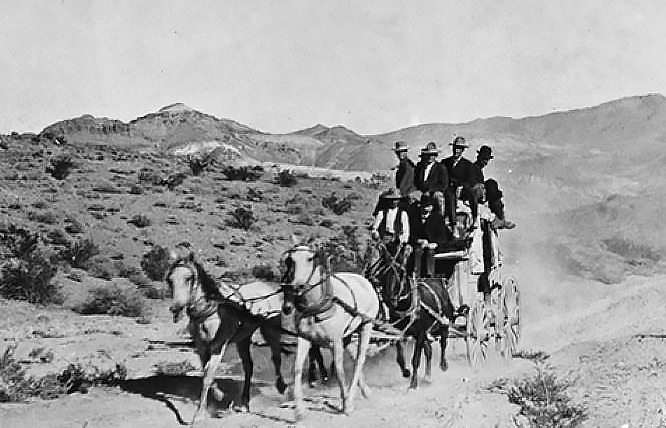
     On October 8, 1858, near midnight, the first Butterfield Overland Mail Stage thundered into Visalia, inaugurating regular, reliable, twice-weekly mail delivery from the east coast for the first time in California’s history.

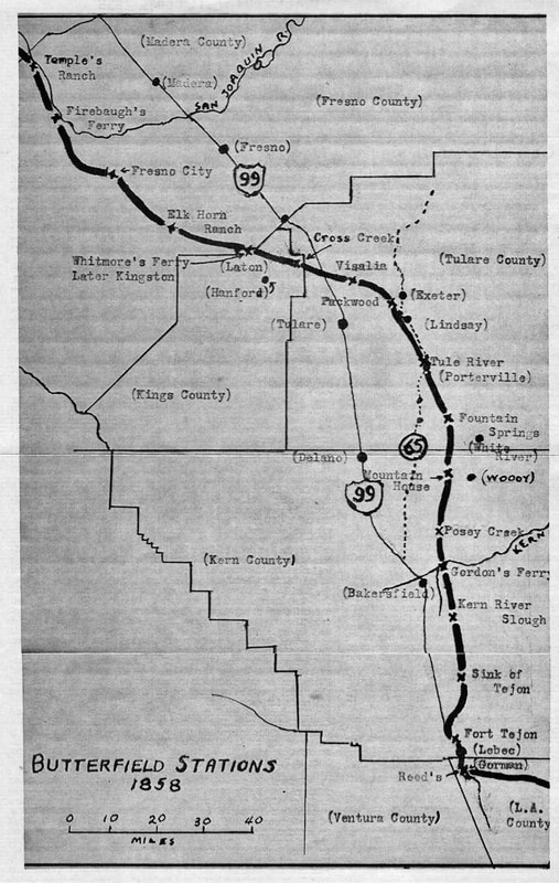
     Both Tulare County and Visalia, its county seat, had been established only six years before, but Visalia, with about 500 residents, was also the oldest San Joaquin Valley town between Los Angeles and Stockton as well as the largest Butterfield way station in what was then a much larger Tulare County. And since Visalia served as an Overland Mail timetable location, it was listed on all of Butterfield’s stage schedule literature.

     A big crowd on Visalia’s Main Street enthusiastically greeted the stage. After its 20-minute stop to change horses and allow the driver and his passenger some food and refreshment (there were no stops for sleep on the Butterfield line), the stage raced away, hailed by a memorable anvil salute. Two days later, the Overland Mail arrived at San Francisco’s post office, completing its arduous 2,800 mile trip from St. Louis in 23 days and 23-1/2 hours, a day ahead of its contract schedule.

     On September 16, 1857, the U.S. government had awarded John Butterfield a $600,000 contract (the largest land-mail contract ever awarded in the U.S. to date) to transport mail twice weekly year-round between St. Louis, Missouri, and San Francisco within 25 days each way. He had to commence that vital service, at such unheard of speed, within just one year.

     Butterfield invested (in association with the principals for Wells, Fargo & Co.) over a million dollars in building or repairing roads and bridges; creating around 150 way stations (eventually about 170), many with living quarters, corrals, barns, and wells; purchasing stagecoaches and ancillary wagons; buying horses, mules, livestock feed, and provisions for staff and passengers; and hiring 800 employees to man the service from Missouri through Arkansas, Indian Territory (now Oklahoma), Texas, New Mexico, Arizona, and California.

     He chose this southern (“Oxbow”) route, although it was hundreds of miles longer than a direct route from St. Louis to San Francisco, because it would avoid the delays caused by having to cross the higher and more numerous mountain ranges to the north, with their severe winter weather.

     His first Overland Mail Stage left St. Louis on September 15, 1858, exactly meeting his contract’s deadline. Abiding by his famous rule, that “Nothing on God’s earth must stop the United States mail,” the Overland Stages almost never failed to get their mail, freight, and passengers through within the 25-day limit. The nation’s rapidly expanding population was thrilled to find itself connected at this astonishing speed.

     But in March, 1860, John Butterfield, facing escalating operational debts, was forced out as president of his Overland Mail Company, and Wells, Fargo and Co. directors (some of his main creditors) took it over. One year later, at the beginning of the Civil War, Congress ordered the overland mail stages to cease service on their suddenly unsafe southern route and move their operation to the “Central Overland California Route” (basically the route of the Pony Express, which operated from April, 1860, until October, 1861, when it was terminated as the transcontinental telegraph line was completed).

     The central route traveled through Nebraska, crossed the Rockies over South Pass to Salt Lake City, then traversed the deserts of Utah and Nevada, struggled over the Sierra Nevada to Placerville, and terminated in San Francisco. Tulare County was no longer on its way.

     The last Butterfield stage on the southern, Oxbow, run left St. Louis on March 18, 1861, and reached San Francisco on April 13. But Butterfield’s trail did not die. Since its inception, his southern route, with its clear course, many improvements, and vital developed water supplies, greatly encouraged and aided emigrant and other travel to the West and California, including Tulare County. Its substantial use continued until the completion of the railroad in 1880.

     As President Buchanan foresaw, in his 1858 congratulatory letter to Butterfield when service commenced on his trail: “It is a glorious triumph for civilization and the Union. Settlements will soon follow the course of the road, and the East and West will be bound together by a chain of living Americans, which can never be broken.”

     In 2023, the Butterfield Overland National Historic Trail (NHT) was added to the National Trails System to commemorate the Butterfield Overland Mail’s impact on the shaping of our nation. In Tulare County, several of the Butterfield stage station sites are commemorated with historic markers, and trail buffs can drive part of the stages’ route today on scenic paved roads.

     Visalia’s marker, at 116 E. Main Street, celebrating the first Butterfield stage’s arrival, is very near where that stage actually stopped, greeted by that famous anvil chorus.

     Lindsay’s marker, at the southwest corner of the junction of Highway 65 and Ave. 228/Hermosa St., memorializes the historic route. Lindsay also honors the Overland Stage with a big (10′ x 45′) colorful mural nearby, at 160 N. Elmwood Avenue.

     Porterville’s Tule River Stage Station marker stands in a little city park, where “Peter Goodhue operated an emigrant trail stopping place on the banks of the Tule River from 1854 until the river changed its course in 1862. This became a Butterfield Overland Mail Stage Station, 1858-61.”

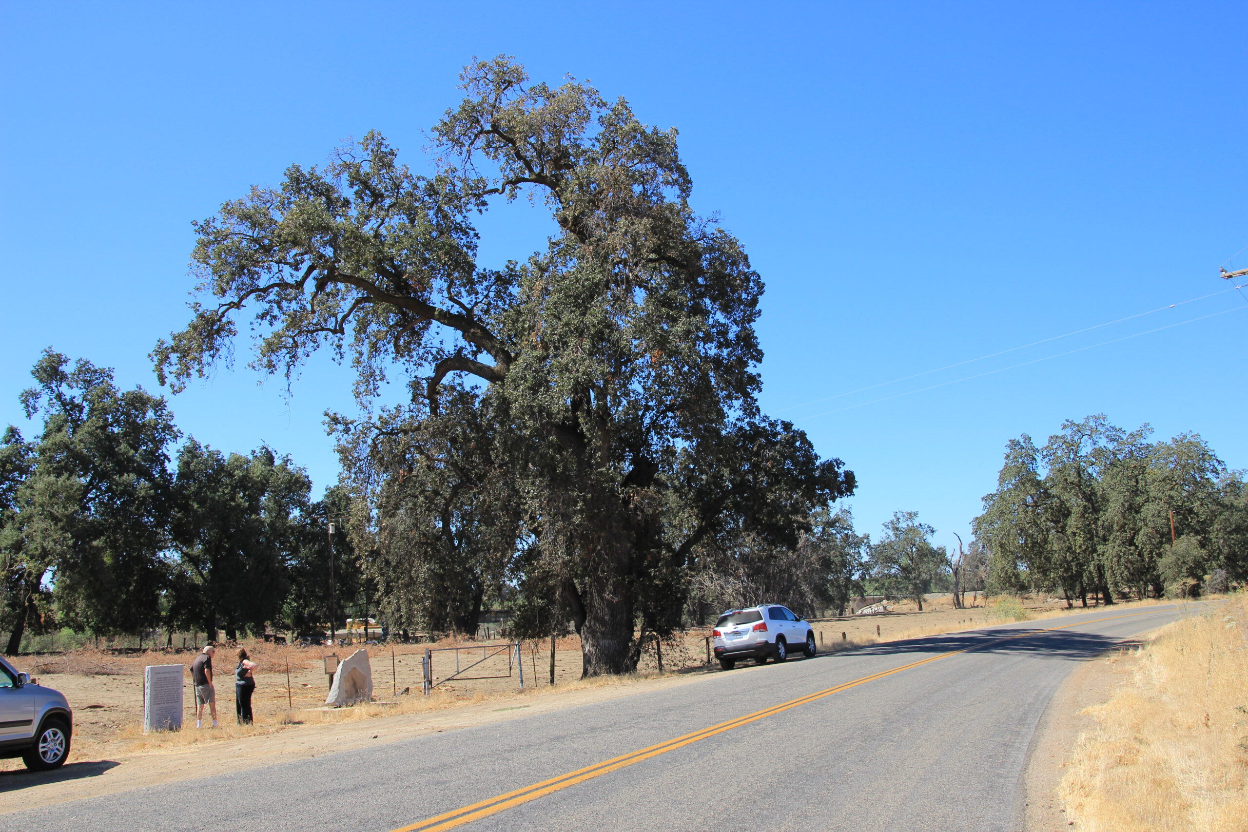
     From Porterville, the historic Old Stage Road leads south to Fountain Springs, where the road’s memorial marker sketches its long history. “Running north and south, following an older Indian Trail is the route . . . [that became] the first public road in Tulare County.” It then lists some of the road’s famous travelers, from Gabriel Moraga’s expedition of 1806 through the Butterfield Overland Stage, 1858-1861.

     An adjacent Fountain Springs marker reads, “One and one-half miles northwest of this point the settlement of Fountain Springs was established before 1855 . . . . From 1858 to 1861, Fountain Springs was a station on the Butterfield Overland Mail route.”

     At Fountain Springs, your wheels have followed Butterfield’s on his legendary trail to its southernmost markers in Tulare County. Imagine how long your trip today would have taken and in what comfort you would have traveled 170 years ago in a storied, jam-packed, jolting Butterfield Overland Mail Stage.

June, 2024


Maps & Directions:


In Visalia, the Butterfield Overland Mail marker is on the north side of E. Main Street, just east of Court St. (and west of N. Church St.), near 116 East Main Street, at 36 19.814N, 119 17.523 W.

From Visalia, take Hwy 198 east to go south (right) onto Hwy 65 to Lindsay.

As you come to Lindsay, at the second stoplight, the intersection of Hermosa St. (Ave. 228) and Hwy. 65, turn right (west) and drive into the gas station on the corner on the south side of the street (235 N. Fremont Dr.). The Butterfield historic marker is just east of the gas station alongside Hwy 65 (at 36 12.148 N, 119 6.256 W; 36.203153, -119.105028), beside a marker for the Fremont Trail.

To see the big outdoor Butterfield mural nearby (at N36 12.198 W119.95.414), take W. Hermosa St. east (it will become E. Hermosa St.) to Elmwood Ave. Turn right [south] on Elmwood and find the mural south of Samoa St. and just north of Honolulu St. at 160 N. Elmwood.

Return to Hwy 65 and go south to Porterville. Take the Henderson Ave. exit east toward N. Main St. The marker is on the SW corner of the intersection with Sunnyside Ave. on your right in the small park dominated by the huge “Salute to the Farmer” statue (N36 04.788, W 119 01.188, 115 E 318132, N 3994687).


Now, go south to Fountain Springs. Proceed east on Henderson to turn south (right) onto N. Plano St. Follow Plano (it will become S. Plano and then Rd. 252) as it finally curves left and becomes Ave. 116. Follow Ave. 116 as it curves south (right) onto Rd. 264 (Old Stage Road) toward Fountain Springs and follow it to its junction with Ave. 56/J22 and Hot Springs Drive to read the historical markers there about Fountain Springs and the Old Stage Road. (Note that the actual Fountain Springs was about 1.5 miles northwest of this intersection.)

(To continue your drive through history, you may want to continue south on Old Stage Road (M109) to White River and the Tailholt State Historical Landmark Tulare County’s historic gold rush territory.)

To return to Visalia, go west on Ave. 56/J22 to Ducor and there go north (right) on Hwy 65 back to Hwy 198 west (left) back to Visalia.

(When leaving Visalia on its way to San Francisco, the Butterfield trail went west to approximately the present route of Hwy 99, where it turned north along that route at Goshen and traced it to about present-day Traver, where it turned west again, leaving Tulare County to cross the Kings River and head for Pacheco Pass.)


Site Details & Activities:

Environment: Valley, Visalia, Lindsay, Porterville, and Fountain Springs
Activities: history, photography, tracing the Butterfield Overland Stage route through Tulare County (and visiting Butterfield Overland Stage mural in Lindsay)
Open: These sites are all outdoors and always accessible; please do your part to keep these sites clean and intact for future visitors to enjoy.
Links: https://www.nps.gov/buov/index.htm Butterfield Overland National Historic Trail


Click on photo for more information.

Atwell Recreation Area AKA Atwell Island Restoration Project AKA Atwell Island Land Retirement Demonstration Site

by Laurie Schwaller

     Conserving 8,000 acres in southwest Tulare County, the Atwell Recreation Area/Atwell Island Restoration Project offers opportunities for bird watching, botanizing, hiking, photography, wildlife viewing, and the enjoyment of wide open spaces and quiet solitude. Visit in the cooler, moister months (usually October to March) and try to imagine how this vast, flat valley land looked a little over a hundred years ago, when it was the site of America’s largest freshwater lake west of the Mississippi , and home for well over 12,000 years to a substantial population of indigenous people who thrived on the great variety of plant and animal life that abounded in its waters and along its shores and neighboring uplands.

     It was also a vital resting, feeding, and nesting site for the millions of migratory birds traveling the Pacific Flyway every year. But this tremendously productive ecosystem was almost completely lost due to intensive irrigated agriculture’s extensive damming, diversions, and pumping of water, eradication of native plants, plowing, planting of commercial crops, and heavy chemical use. These operations on the area’s perched water table eventually prohibited proper drainage in the root zone, which led to deadly salinization, uneconomical farming, and the Central Valley Improvement Act (CVIA) of 1992.

     Since then, the Bureau of Land Management and many partners, including the Bureau of Reclamation, the Fish and Wildlife Service, public interest and environmental organizations, schools, AmeriCorps crews, and lots of volunteers have been working to assess the effects of voluntary land retirement on drain water and ground water levels and its potential to decrease bioavailable selenium and other toxic compounds, along with developing and determining costs of effective restoration technologies for re-establishing native plants and animals on these sites and determining wildlife’s responses to these efforts.

     Nowadays, visitors enjoy walking the trail that circles the restored wetland area, and birdwatching from its viewing platform above the water. Beyond the wetland, hundreds of acres of voluntarily-retired marginal farmland are being restored to native valley grassland and alkali sink habitats, providing living space for animals such as mountain plovers, Tipton’s kangaroo rats, San Joaquin kit foxes, burrowing owls, horned lizards, tricolored blackbirds, blunt-nosed leopard lizards, and other imperiled species. Someday, perhaps even natives such as pronghorn and Tule elk could be returned to roam the Atwell plains again. What a gift that would be for wildlife and for those exploring this vast, revitalizing ecosystem.

August, 2025

NOTE: The Project Team will be conducting research for a full article as volunteer time allows.  Contact us if you’d like to help research, write about, and/or illustrate this Treasure.


Maps & Directions:


Latitude/longitude: 35.84506, -119.4975

From Visalia, take Hwy 198 west to Hwy 99 south to Earlimart.  There, take exit #65 west (right) onto County Road J22/Avenue 56 (which becomes Avenue 54) to Alpaugh (about 12 miles west of Earlimart).

In Alpaugh, turn left (south) on Road 38, which will soon jog east and then continue south as Road 40, about 2 miles to the signs for Atwell Island. Continue straight on the graveled road and follow signs about 1 mile to the wildlife viewing platform in the Ton Tache Wetlands.

Nearby Treasures: Colonel Allensworth State Historic Park, Pixley National Wildlife Refuge, Allensworth Ecological Reserve, Alpaugh Park


Site Details & Activities:

Environment: Valley; south of Alpaugh; restored wetlands, wildlife viewing platform; 8,000 acres of native valley grassland and alkali sink habitats being restored on an area farmed for the past century (now voluntarily retired); no other visitor facilities yet
Activities: birding, botanizing, hiking, nature study, photography, wildlife viewing; viewing platform and limited dirt roads are only visitor facilities to date (camping available nearby at Colonel Allensworth State Historic Park; picnic tables, playground, and restroom at Alpaugh Park)
Open: daily, sunrise to sunset, weather permitting, unless closed due to emergency conditions; no fee
Site Steward: U.S. Department of the Interior, Bureau of Land Management, Bakersfield Field Office; 661-391-6000; https://www.blm.gov/visit/atwell-recreation-area
Opportunities for Involvement: donate, volunteer
Links: https://www.blm.gov/visit/atwell-recreation-area


Click on photo for more information.

Bearpaw High Sierra Camp for “Luxuries” in the Wilderness

by Laurie Schwaller


     Tucked at 7800 feet elevation into the north slope of the vast valley of the Middle Fork of the Kaweah River in Sequoia National Park, iconic Bearpaw High Sierra Camp offers travelers on the spectacularly scenic High Sierra Trail the luxuries of cozy beds, tent cabins, real meals, and hot showers in the wilderness. It opened in 1934, is listed on the NRHP, and, accommodating only 12 guests per night, by reservation only, to rave reviews, is still the sole wilderness lodging in Sequoia and Kings Canyon national parks.


May, 2025

NOTE: The Project Team will be conducting research for a full article as volunteer time allows.  Contact us if you’d like to help research, write about, and/or illustrate this Treasure!  

Maps & Directions:


Latitude: 36.565330 Longitude: -118.620986

Bearpaw High Sierra Camp is accessible only by foot/stock on the High Sierra Trail in Sequoia National Park.

From Visalia, drive east on Hwy 198 through Three Rivers to the Park entrance (fee). Continue on Hwy 198 (now Generals Highway) up the mountain to just before the Giant Museum and turn right onto the Moro Rock/Crescent Meadow Road. Bear left when the Moro Rock road goes off to the right and continue to the end of the Crescent Meadow Road. The High Sierra trailhead is near the restrooms at the southeast end of the parking lot. (Shuttle transportation to Crescent Meadow is also available in the summer.)

Bearpaw High Sierra camp is about 11.5 miles up the High Sierra Trail.

NOTE: Wilderness permit required to overnight on the High Sierra Trail. Reservation required to stay overnight at Bearpaw High Sierra Camp.


Site Details & Activities:

Environment: Mountains, mixed conifer forest, great views, elevation 7,800′, alongside the High Sierra Trail
Activities: architecture study, backpacking, birdwatching, botanizing, camping, fishing (with valid license and in compliance with state and local regulations), hiking, picnicking, photography, visiting giant sequoia groves (at Crescent Meadow), wildflower and wildlife viewing
Open: Sequoia National Park is always open, weather permitting, unless closed due to emergency conditions; park entrance fee. Bearpaw High Sierra Camp is typically open mid-June to mid-September, depending on weather and road conditions. Reservations are required and often fill quickly, though cancellations may open a spot. Wilderness permit required to overnight on the High Sierra Trail.
NOTE:  Bearpaw High Sierra Camp is currently unavailable until further notice.
Site Steward: Sequoia National Park concessioner, currently Delaware North Companies: for reservations and more information, visit www.visitsequoia.com or call 866-807-3598.
Opportunities for Involvement: donate, volunteer, Sequoia National Park, Sequoia Parks Conservancy; employment at Bearpaw High Sierra Camp (Delaware North Companies)
Links:
www.visitsequoia.com


We see a long view of the low gray-green San Joaquin Valley scrub brush growing in the flat, dusty, cracked alkali habitat of Allensworth Ecological Reserve, with a cloudy sky above the long, straight horizon.

We see a long view of the low gray-green San Joaquin Valley scrub brush growing in the flat, dusty, cracked alkali habitat of Allensworth Ecological Reserve, with a cloudy sky above the long, straight horizon.

Click on photo for more information.

Visiting Allensworth Ecological Reserve

by Laurie Schwaller

     The valley sink scrub community found at Allensworth Ecological Reserve is one of the best remaining examples of this rare alkali habitat in the southern San Joaquin Valley. Since 1980, the state of California has been purchasing land in this area, initially to protect habitat for imperiled species including the San Joaquin kit fox, blunt-nosed leopard lizard, and Tipton kangaroo rat, along with several other special status species and natural communities. The property was designated as an ecological reserve by the State Fish and Game Commission in 1983.

     Funding for these ongoing purchases has come largely through the State Wildlife Conservation Board, which does not provide funds for managing the lands. Thus, while the Reserve is conserved in perpetuity for the protection of lands vital to sensitive native species included in the Recovery Plan for Upland Species of the San Joaquin Valley, funds for management, monitoring, and maintenance by the California Department of Fish and Wildlife depend on allotments from the state’s general fund.

     Visitors exploring this flat land of valley sink scrub and valley saltbush scrub will see iodine bush, goldenbush, atriplex, and San Joaquin saltbush, ground squirrels, and possibly a coast horned lizard or two, along with native and migrating birds in season. Caution: Summer temperatures are very high, there are no visitor facilities, and there is virtually no shade. Carry water.


March, 2022


NOTE: The Project Team will be conducting research for a full article as volunteer time allows.  Contact us if you’d like to help write about this Treasure


Maps & Directions:


From Visalia, take Hwy 99 south to Earlimart and exit west on County Road J22 (Ave. 56).

In about one mile, turn left (south) onto Howard Road.

In about two miles, turn right (west) onto Avenue 40.

Proceed about one mile to the Allensworth Ecological Reserve gate, where parking is available.

Access the reserve on foot, through the gate.

Nearby Treasures: Pixley National Wildlife Refuge, Colonel Allensworth State Historic Park, Alpaugh Park, and Atwell Island Land Retirement Demonstration Site/Atwell Island Recreation Site


Site Details & Activities:

Environment: Valley; south of County Rd. J22, mostly between Hwy 99 and Hwy 43; over 5,000 acres of mostly flat native valley sink scrub and saltbush scrub habitat on land previously used primarily for farming, grazing, and non-toxic waste disposal; no visitor facilities yet
Activities: birding, botanizing, hiking, nature study, photography, wildflower and wildlife viewing (seasonal); foot travel only for visitors inside the reserve; no visitor facilities (camping available nearby at Colonel Allensworth State Historic Park; picnic tables, playground equipment, and restroom at Alpaugh Park); all visitors are responsible for knowing and following public use regulations for this area: see CDFW Public Lands Regulations
Open: daily, sunrise to sunset, weather permitting, unless closed due to emergency conditions; no fee
Site Steward: California Department of Fish and Wildlife, Central Region; 559-243-4014
Opportunities for Involvement: Donate, volunteer
Links: Visitor Information


Two simple, rustic, one-story buildings that serve as the Cabin Creek Ranger Station and Dormitory nestle amid the tall straight trunks of the mixed conifer forest in Sequoia National Park. Made of wood, and painted the traditional brown and green to blend with the trees, they have stone chimneys and native granite facing on their foundations to further harmonize them with their beautiful natural surroundings.


Two simple, rustic, one-story buildings that serve as the Cabin Creek Ranger Station and Dormitory nestle amid the tall straight trunks of the mixed conifer forest in Sequoia National Park. Made of wood, and painted the traditional brown and green to blend with the trees, they have stone chimneys and native granite facing on their foundations to further harmonize them with their beautiful natural surroundings.

Click on photo for more information.

Visiting Cabin Creek Ranger Residence and Dormitory

by Laurie Schwaller

     Civilian Conservation Corps (CCC) workers in Sequoia National Park built the Cabin Creek Ranger Residence and Dormitory in the summers of 1934-1935. The National Register of Historic Places listed these buildings in April, 1978, as excellent examples of National Park Service rustic architecture, which emphasized the design relationship between structures and their natural setting.

     These two small buildings nestle within the dense growth of the mixed conifer forest that screens them from the park’s busy Generals Highway, at 6,800′ elevation. Their simple, single-story design, with wooden walls and shingled roofs, stone chimneys, brown and green exterior paint, sheltering porches front and rear, and native granite facing on their concrete foundations, blends them harmoniously with the surrounding trees. They face east, toward Cabin Creek.

     The residence and dormitory provided housing for rangers staffing the new park entrance station (long since closed) at Lost Grove on the just-completed section of the Generals Highway linking Sequoia National Park and Grant Grove National Park (which became part of Kings Canyon National Park when it was established in 1940). In 2009, the Parks’ historic preservation crew, led by Thor Riksheim, authentically restored these structures. And so, these pleasingly rustic buildings continue to look as they always have, tucked familiarly among the tall trees that shelter them, and still serving to lodge Park personnel and work crews.

March, 2022


NOTE: The Project Team will be conducting research for a full Treasure Tale article page as volunteer time and resources allow.  Contact Us if you’d like to help research, illustrate, and/or write about this Treasure!


Maps & Directions:


Directions:

Cabin Creek Ranger Residence and Dormitory are located in Sequoia National Park, near Dorst Campground.

From Visalia, drive east on Hwy 198 through the town of Three Rivers to the Park entrance (fee). Follow Hwy 198 (called the Generals Highway in the Park) up the mountain to Dorst Campground.

The Ranger Residence and Dormitory are located approximately two miles beyond (northwest of) the campground and down a driveway off the east side of the highway.


NOTE: These buildings are Park residences. Please respect the occupants’ privacy. Do not approach these buildings.


Site Details & Activities:

Environment: Mountains, mixed conifer forest, elevation 6,800 feet, in Sequoia National Park
Activities: architecture study, history, photography (exterior only)
Open: Sequoia National Park is always open, weather permitting, unless closed due to emergency conditions; park entrance fee. Note: These buildings are Park residences. Please always respect the occupants’ privacy. Do not approach these buildings.
Opportunities for Involvement: Donate, volunteer


Park scene with a picnic table on a lawn and child's play structure in the background on a sunny day.

Park scene with a picnic table on a lawn and child's play structure in the background on a sunny day.

Click on photo for more information.

Visiting Alpaugh Park

by Laurie Schwaller

     In January, 1935, the Tulare County Board of Supervisors purchased land in the little town of Alpaugh to be used for parks and other county purposes. County workers developed approximately two acres to serve as the community’s park. They planted a lawn and young fruitless mulberry trees, then added several picnic tables and a fire pit. Alpaugh Park now includes a restroom building and a shady picnic arbor that can be reserved. In 2020, the County installed colorful modern play structures near the old metal slide for youngsters to enjoy.      

March, 2024

NOTE:  The Project Team will be conducting research for a full article page as volunteer time allows.  Contact us if you would like to help research, write about, and/or illustrate this Treasure!


Maps & Directions:


Directions:

 From Visalia, take Hwy 198 west to Hwy 99 south to Earlimart and exit west on County Road J22 to Alpaugh (about 13 miles west of Earlimart).

In Alpaugh, turn right (north) on Road 38. The park is on Road 38 at the northwest corner of Tule Road and Park Avenue, across from the Alpaugh Memorial Building.


Nearby Treasures: Pixley National Wildlife Refuge, Colonel Allensworth State Historic Park, Atwell Recreation Area/Atwell Island Restoration Project, and Allensworth Ecological Reserve.


Site Details & Activities:

Environment: Valley; in Alpaugh; approximately 2 acres; trees, lawn, restroom, picnic arbor, picnic tables, fire pit, playground equipment, small sports field
Activities: dog-walking (on leash; scoop poop), picnicking, playground equipment (slides and swings with shade structures)
Open: daily Thursday-Monday for day use only (closed Tues. and Wed.); Summer (June 1-September 8): 8:00 a.m.-8:00 p.m.; Fall (Sept. 9-Oct. 31): 8:00 a.m. – 7:00 p.m. on Sat. and Sun.; Winter (Nov.-Feb.): 8:00 a.m.-5:00 p.m.; Spring (Mar.-May): 8:00 a.m.-5:00 p.m. on Mon., Thurs., and Fri.; 8:00 a.m.-7 p.m. on Sat. and Sun. No entrance fee. Reservations for picnic arbors are taken throughout the year.
Site Steward: Tulare County Parks and Recreation Division, 559-205-1100; same number for reservations. Reservations can also be made online:
Opportunities for Involvement: Donate, volunteer