Many Treasures are still awaiting their Treasure Tales, which we’ll research and write as soon as time and other resources allow. When their pages are complete, you’ll find them under the Treasure Tales Alphabetized tab. Meanwhile, we’ll be providing basic information for them as quickly as we can here in the Articles Pending section. If you’d like to help to do research for, write, or illustrate these pending pages, please Contact Us.
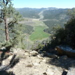
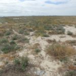
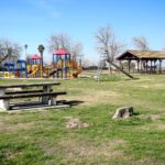
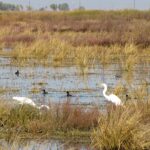
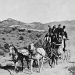
Visit Allensworth Ecological Reserve to explore its valley sink scrub community, one of the best remaining examples of this rare alkali landscape in the southern San Joaquin Valley, protecting habitat for imperiled species including the San Joaquin kit fox, blunt-nosed leopard lizard, and Tipton kangaroo rat, along with several other special status species and natural communities, Visitors hiking this flat land of valley sink scrub and valley saltbush scrub will see iodine bush, goldenbush, atriplex, and San Joaquin saltbush, ground squirrels, and possibly a coast horned lizard or two, along with native and migrating birds in season. In January, 1935, the Tulare County Board of Supervisors purchased land in the little town of Alpaugh to be used for parks and other county purposes. County workers developed approximately two acres to serve as the community’s park. They planted a lawn and young fruitless mulberry trees, then added several picnic tables and a fire pit. Alpaugh Park now includes a restroom building and a shady picnic arbor that can be reserved. In 2020, the County installed colorful modern play structures near the old metal slide for youngsters to enjoy. In Tulare County’s southwest corner, Atwell Recreation Area, once the site of America’s largest freshwater lake west of the Mississippi, and home for over 12,000 years to Native Americans, is now the gateway to 8,000 acres of former farmland voluntarily retired and conserved under the 1992 Central Valley Improvement Act — a vital ecosystem being studied and revived by the Atwell Island Restoration Project. Walk the wetland area trail, enjoy birdwatching from its viewing platform, and botanize and watch for wildlife in its native valley grassland and alkali sink habitats in the cooler months. Tucked at 7800 feet elevation into the north slope of the vast valley of the Middle Fork of the Kaweah River in Sequoia National Park, iconic Bearpaw High Sierra Camp offers travelers on the spectacularly scenic High Sierra Trail the luxuries of cozy beds, tent cabins, real meals, and hot showers in the wilderness. It opened in 1934, is listed on the NRHP, and, accommodating only 12 guests per night, by reservation only, to rave reviews, is still the sole wilderness lodging in Sequoia and Kings Canyon national parks. Follow the famous Butterfield Overland Mail Stage Route from Visalia to Fountain Springs, read the historical markers along the way, and imagine journeying these miles in a rattling, bouncing Butterfield stage. In 1857, the U.S. government awarded John Butterfield the largest land-mail contract ever awarded in the U.S. at that time to transport mail (the stages carried passengers, too) twice weekly year-round between St. Louis, Missouri, and San Francisco (almost 2,800 miles) within 25 days each way. Butterfield’s revolutionizing stages passed through much of Tulare County, with Visalia an important timetable stop. A short distance off the Generals Highway in Sequoia National Park you can get a glimpse of real living history. CCC workers built the Cabin Creek Ranger Residence and Dormitory here in 1934-35 to house Park rangers working at the Lost Grove entrance station (now long closed) on the newly-completed Generals Highway. These two small buildings are excellent examples of National Park Service rustic architecture, built simply, with natural and native materials, to blend harmoniously with their forest surroundings. They still serve as Park residences; please always respect occupants’ privacy. Sequoia National Forest’s super scenic Cannell Meadow National Recreation Trail runs south 23.7 rugged miles from 9200′ elevation at Sherman Pass on Tulare County Road J-41 to about 2600′ just south of our county line above Kernville and Lake Isabella. Open year-round (check for snow closures in winter), no fee or permit required, for hiking, horseback riding, and mountain biking (middle section closed to motorized use), this challenging trail travels through mixed pine and fir forest, meadows, and chaparral, with plenty of major ups and downs, ending in its epic 9-mile-long, 5,000′ Plunge Miles of scenic year-round hiking, biking, and equestrian trails in BLM’s Case Mountain Recreation Area lead through beautiful foothill oak woodlands, up the mountain to Salt Creek Falls, and on through mixed conifer forest to giant sequoia groves and panoramic vistas from the 6,800′ crest (over 10 miles and 6,500′ of elevation gain from the Skyline Drive and Craig Ranch trailheads in Three Rivers). A grand, easily accessible resource for backpackers, campers, dog walkers, equestrians, fisher folk and hunters (seasonal, license required), picnickers, photographers, and wildflower and wildlife lovers. Find the historic Cattle Cabin in Sequoia National Park’s Giant Forest, just south of the majestic Founders Group on the scenic Circle Meadow Trail. This simple, sturdy shelter recalls the many years when foothill ranchers, beginning with Hale Tharp, in 1861, drove many hundreds of cattle here annually for summer grazing, and eventually added dairy operations — and a Circle Meadow slaughtering corral, to supply fresh milk and meat to the growing populations of workers and tourists thronging the Forest. Can you imagine those days in the timeless, irreplaceable landscape surrounding you today? A short, pleasant drive east of Visalia takes you to Tulare County’s beginning, in the shade of magnificent oak trees, just north of the Kaweah River and a half mile from Woodsville, the tiny “permanent” Euro-American settlement (and thus official seat) of this new county the State legislature created in April, 1852. Beneath this fabled Charter Oak (or one nearby), residents met in July, 1852, to vote in Tulare County’s first election, to organize the county. Then, In 1853, upstart Visalia was elected the county seat instead. Woodsville died. The oaks abide. Tulare County’s southeast corner contains most of rugged, scenic Chimney Peak Wilderness, over 13,000 acres of pinyon pine covered mountains (Chimney Peak reaches almost 8,000′), occasional springs and streams supporting lusher riparian areas (find trout in Chimney Creek), desert plants including Joshua trees and creosote bush in the lower elevations, and sage brush in between, home to bears, mule deer, bobcats, mountain lions, wonderful wildflowers (seasonally), plenty of solitude, plus eight miles of the Pacific Crest National Scenic Trail, and the Chimney Peak Backcountry Byway along its boundary line.ALLENSWORTH ECOLOGICAL RESERVE
ALPAUGH PARK
ATWELL RECREATION AREA
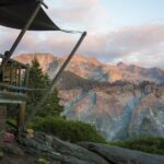
BEARPAW HIGH SIERRA CAMP
BUTTERFIELD OVERLAND MAIL STAGE ROUTE
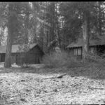
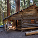
CABIN CREEK RANGER RESIDENCE
CANNELL MEADOW NATIONAL RECREATION TRAIL
CASE MOUNTAIN EXTENSIVE RECREATION MANAGEMENT AREA
CATTLE CABIN, SEQUOIA NATIONAL PARK
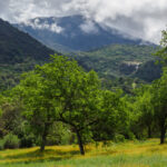
CHARTER OAK AKA ELECTION TREE
CHIMNEY PEAK WILDERNESS